Page 16 of 19
Re: [Map] Operation Tempest (4km) [WIP]
Posted: 2011-10-24 02:40
by ChiefRyza
Back to working on it full time as we speak

Posted: 2011-10-24 06:20
by dtacs
Congo done then? Dev blog kgo
Re: [Map] Operation Tempest (4km) [WIP]
Posted: 2011-10-25 01:19
by Shovel
[quote=""'[R-CON"]ChiefRyza;1686182']working[/quote]
[quote="dtacs""]done[/quote]
not equal.
Re: [Map] Operation Tempest (4km) [WIP]
Posted: 2011-10-25 02:12
by Psyrus
[quote=""Thread_Title"]Operation Tempest[/quote]
[R-CON]ChiefRyza wrote:Back to working on it
[quote="dtacs""]
Congo done then?[/quote]
As you like to say:
Shovel wrote:not equal.

Re: [Map] Operation Tempest (4km) [WIP]
Posted: 2011-10-25 02:14
by Shovel
Oh lol wow. Sorry about that.
Posted: 2011-10-25 02:16
by dtacs
Edit: Nvm, misread.
Re: [Map] Operation Tempest (4km) [WIP]
Posted: 2011-10-26 00:12
by Stealthgato
Sweet. This map is promising.
Re: [Map] Operation Tempest (4km) [WIP]
Posted: 2011-10-26 01:02
by ChiefRyza
Yeah sorry, I should have specified that

Congo will come after Operation Tempest, and a third map if time permits after that but I want to focus on Operation Tempest to completion, then Congo, then Yunnann Mountains.
Now I've gotten Uni out of the way for this year I have so much more time to get it finished. I had to cut it down size wise by a large amount to reduce the overgrowth count, but the island archipelago is still fairly big in size. Ill add an updated range of screenshots here on the weekend, of course, I'll be playing my fair share of BF3 before that!
Re: [Map] Operation Tempest (4km) [WIP]
Posted: 2011-10-26 07:03
by Pvt.LHeureux
[R-CON]ChiefRyza wrote:Yeah sorry, I should have specified that
Congo will come after Operation Tempest, and a third map if time permits after that but I want to focus on Operation Tempest to completion, then Congo, then Yunnann Mountains.
And Stranded?
But, 3 maps now

. Any screens of Yunnann Mountains?

Also are the links down on the original post? Can't seem to load the pictures. Looks like you deleted all the links.
Re: [Map] Operation Tempest (4km) [WIP]
Posted: 2011-10-26 08:20
by pfhatoa
Yunnann Mountains
Lovely choice of area

Re: [Map] Operation Tempest (4km) [WIP]
Posted: 2011-10-27 08:50
by ChiefRyza
This will be the last update before I put everything further into the R-CON mapping section. I just wanted everyone to see that it is still going ahead and I'm going to put as much time into it as possible to get it finished these Christmas holidays.
Here is a photoshopped minimap, because I havn't gone through and done the proper one yet. Its very close to how it will look terrain wise. Objects are still wip as a lot of flags and areas of interest need to be redone. The map is fairly small playable area for a 4km map, but I hope this will make for a unique 4km map experience. Jets are still planned so it will be interesting to see how they play out when I get around to beta testing.
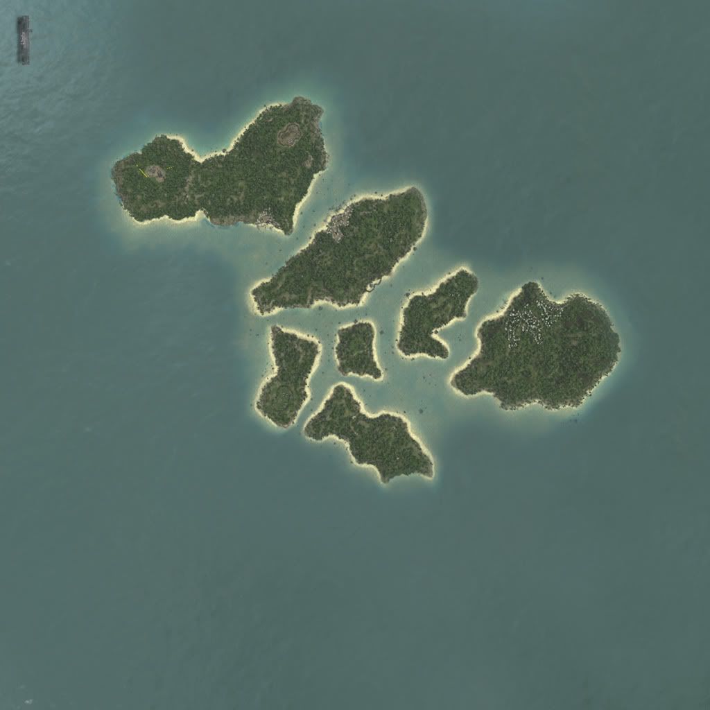
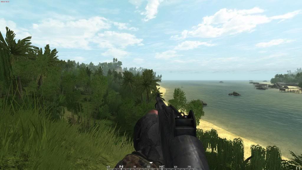
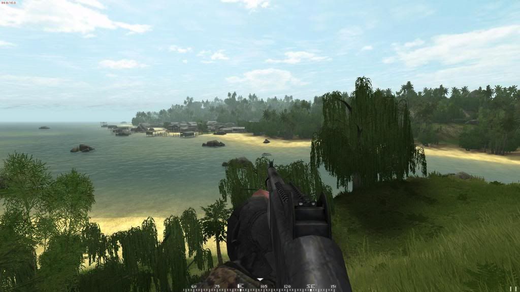
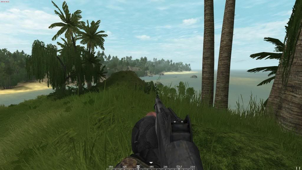
These are screenshots from the first island, I apologize that they are similar to the other ones previously shown, but I decided to revert to the old lighting.
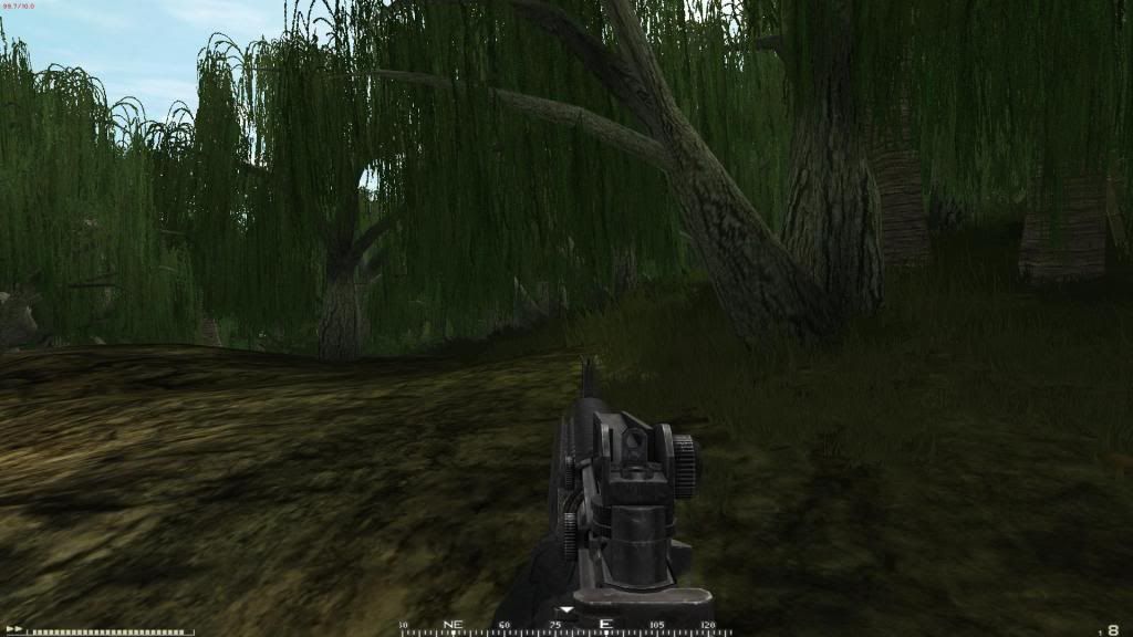
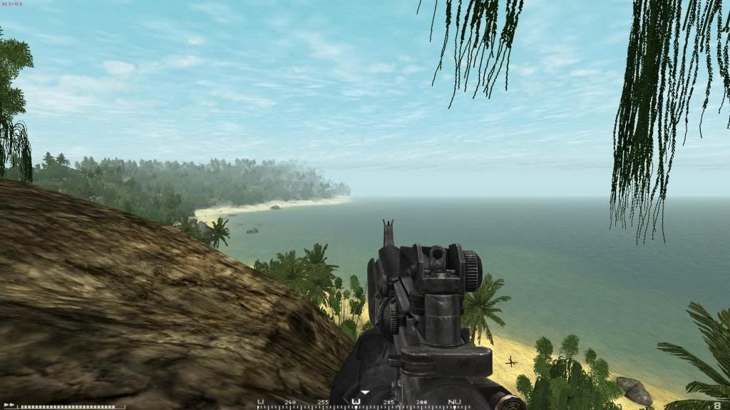
It has taken a very long time to work out what works and what doesn't as well as building it to a stage I'm happy with. I had to remove a massive island that was to the south east for the overgrowth count to be stable, and ended up hand painting the map for it to look the way I wanted.
Now that the general visual feel is done, I can focus on making the flag areas and filling the whole thing out.
Re: [Map] Operation Tempest (4km) [WIP]
Posted: 2011-10-27 09:02
by Jafar Ironclad
Looks like it'll be a dream to fly/fight in. Fantastic so far!
Might I suggest placing the carrier on the northeast or southwest corner of the map, so it isn't visible from land?
Re: [Map] Operation Tempest (4km) [WIP]
Posted: 2011-10-27 09:18
by ChiefRyza
It isn't visible in game from the island, don't worry
That minimap isnt 100% accurate either, its the terrain captured from high up in the editor and then manually put water in, as well as the carrier. I just wanted to show people what it would look from above. It's well out of range and the ARF/A.U have no means to attack it from the first island. Too far away and it will be a long trip for the AAV's to hit the beach, as they are still the main initial means of landing.
Re: [Map] Operation Tempest (4km) [WIP]
Posted: 2011-10-27 09:35
by IINoddyII
Looks great Ryza - so much looking forward to this map.
Re: [Map] Operation Tempest (4km) [WIP]
Posted: 2011-10-27 09:37
by dtacs
Looks good, utterly different to the original but awesome. Couple of questions;
Where exactly is the AU main and can an AAVP or whatever to sit in the water camping the entrance? Can they use supply trucks to drive across the sandbars?
And have you considered alternate carrier placement? It seems wasteful with some 30% of the maps southern chunk being water, void of feature. I'm concerned that with Hueys, the US will have the ability to flank ludicrously far around the chain and build unrealistic firebases. I know its something I'd do, avoiding a realistic amphibious assault on the first flag entirely.
I know its too quick to judge before gameplay testing but it seems that without the linearity of the original, the concept of large-scale combined arms is lost or discouraged when alternative (and safer) tactics are available.
Re: [Map] Operation Tempest (4km) [WIP]
Posted: 2011-10-27 09:49
by ChiefRyza
Good points dtacs - The carrier placement matches the setup however, as it goes from the NW island, to the very SE island with the large town (where the AU main is). Anywhere else and it will break the flow of the map, as the AAV's are meant to strike the initial beach head at the north of the first island. I will look into combat zones, maybe they can be coded dynamically as I originally thought of. The problem of a beach assault map is that there are always going to be people trying to set up in the most out of place positions (Barracuda for example).
In addition to this, the ARF will have spawns attached to the flag in contest for each island, these spawns will be bases at the rear of the island so you won't have enemies spawning on the capture zones. Once the flag is captured by the Marines it cannot be retaken, and spawning is completely disabled on that flag, forces all the ARF to spawn on the next objective's island. It is still a surprisingly long walk along the islands so I am hoping that although people may be able to build firebases anywhere, it would be fairly pointless considering to move to an objective they have to cross open water onto an island crawling with enemies anyway.
Again, will have to put it through some rigorous testing to nail down these problems but I'm sure it will work out.
Re: [Map] Operation Tempest (4km) [WIP]
Posted: 2011-10-27 10:14
by dtacs
Excellent idea. Will these spawns be the typical 12-count ones until they vanish? Look forward to seeing this idea in practice, AASV4 at its finest.
Re: [Map] Operation Tempest (4km) [WIP]
Posted: 2011-10-27 10:17
by pfhatoa
It's a hard manoeuvre but wouldn't it be good all the islands some steps south, 500-1000m to increase the distance between the carrier and the islands. But, yea, it's a hard work

Re: [Map] Operation Tempest (4km) [WIP]
Posted: 2011-10-27 11:26
by ChiefRyza
Tried it, moving the heightmap is extremely simple but the colormap is another story, as it is split up into lots of files. Really didn't want to retexture everything so for now I will leave it.
Re: [Map] Operation Tempest (4km) [WIP]
Posted: 2011-10-27 12:18
by pfhatoa
Isn't there a utility somewhere around he that can stitch the parts together and then chomp em up again. If not I guess you can use the program Fiji, it can stitch images together according to a naming convention. See:
Stitching 2D/3D - Fiji
It's open source and all, used for biological scans and so on if I remember correctly.