
I'd like to see certain things, such as rivers, canals, and other bodies of water, along with grass, forest, mountain and ROADS most importantly to be more pronounced in the mini map. Its very difficult to navigate on some maps (can't remember the exact map, but it has west beach, east beach, dam, bridge, etc. US vs China).
I just want to see roads more pronounced on the minimap, so we know there are roads, and we know how to drive to the battlefield. A lot of the roads are counter intuitive, they twist and turn, vehicles have torque issues and can't really move up hilly terrain, such as the mobile AA. So I think that making roads and paths more pronounced would prevent getting lost on some of the more confusing maps.
*waits for Vikingo to tell me I have to memorize the maps, because thats what he has done*
What do you guys think?
Hard to navigate with ambigious looking maps.

-
Guerra norte
- Posts: 1666
- Joined: 2006-07-19 17:37

-
DirtyHarry88
- Posts: 1540
- Joined: 2006-12-24 18:41
-
jerkzilla
- Posts: 1615
- Joined: 2007-03-07 12:04
I don't think the maps in the game are actual maps as posted above, but more like a satellite photo of the area with a bunch of icons on it...
I'd like to see roads marked with red, kinda like in Battlefield Vietnam I think, water isn't causing me that many problems.
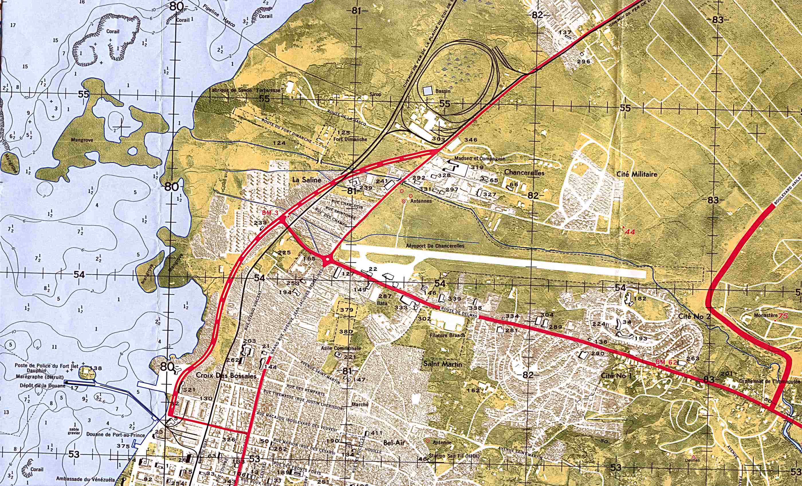
Oh, and by the way, that map is Jabal Al Burj and it's U.S. Marines versus M.E.C.
I'd like to see roads marked with red, kinda like in Battlefield Vietnam I think, water isn't causing me that many problems.
Oh, and by the way, that map is Jabal Al Burj and it's U.S. Marines versus M.E.C.
-
Guerra norte
- Posts: 1666
- Joined: 2006-07-19 17:37


-
Smash-Crunch
- Posts: 143
- Joined: 2006-11-29 01:56
-
Guerra norte
- Posts: 1666
- Joined: 2006-07-19 17:37
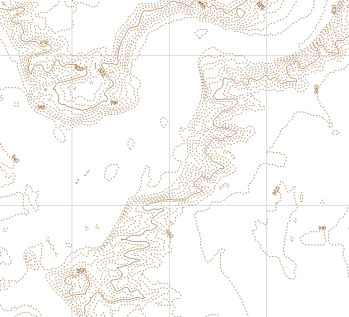
Smash-Crunch wrote:The contour lines on that top map are useless without any measurements,
Uhh yes they are, what do you mean by measurements? Like a line that shows distances? Well there is one and it's dynamic too, it's just not showing on the screenshot I took.
You mean like markers? Of course there's is none, I haven't put out any.Smash-Crunch wrote:plus theres no legend.
I might also add that the map is very dynamic when zooming in and out so you get a different level of detail avoiding getting lots of clutter when zooming far out.
-
ubiquitous
- Posts: 115
- Joined: 2007-03-02 21:53
-
Top_Cat_AxJnAt
- Posts: 3215
- Joined: 2006-02-02 17:13
For those of you not living in a properly mapped country, which is pretty much every one not in the UK, or possible a few EU countries, this is what a map should and for those who like to say "Ich bin ein Berliner!", this is for you:

I do realise the middle east, will never be mapped in such detai, but hell really, maps like these are the basis for what maps in RL should look like, and therefore a bench mark for PR to consider, but most certainly will never attain using the present game - not a problem though due to engine map size, object, terrain limitations.
I also realise, there almost certianly will be some difference between the above and military maps, although i am sure the British Army would not be too badely handicapped using OS maps if all came to the worse in an all out war over the UK.
For those desperate to see some more hardcore map pornography!:
ENJOY
Last edited by Top_Cat_AxJnAt on 2007-03-22 21:17, edited 1 time in total.
-
El_Vikingo
- Posts: 4877
- Joined: 2006-11-27 01:50

-
ubiquitous
- Posts: 115
- Joined: 2007-03-02 21:53
To be fair the OS are lords of all things map. Not sure the military have a lot of use for a map that tells you where you can park your car though  .
.
Here are some real military maps that I found:
Israeili
US
Soviet (looks kind of like the Arma one)
Here are some real military maps that I found:
Israeili
US
Soviet (looks kind of like the Arma one)
-
Guerra norte
- Posts: 1666
- Joined: 2006-07-19 17:37
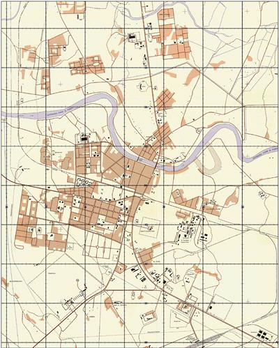
Lol, while we're at it, here's a map of a real iraqi city (Samawah) in VBS1 terrain pack module 3.
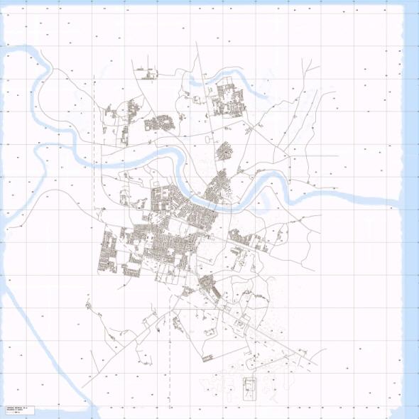
Here's a real US army map of the city.
Go HERE for high-res versions.
Here's a real US army map of the city.
Go HERE for high-res versions.
-
Clypp
- Posts: 2148
- Joined: 2006-07-17 18:36
Topographical maps are possible. I saw one of the map makers once present one of the maps (Jabal I think) as a topographical style map. They complained that filling in the buildings would take too long but using an overlay of the normal map can do this quite easily. I would love to see the maps the military uses in game.
-
[-=IDSF=-]SykloAG
- Posts: 403
- Joined: 2006-11-25 12:56
Yeah those ArmA maps are cool. Most of the maps I saw while serving were aerial or satellite with contour lines etc overlaid on top and a legend on the side.
[EDIT]
Hmm... On second thought Al-Basrah is somewhat lacking in topography... I'll do some other map - Hills of Hamgyong would be more appropriate.
[/EDIT]
I'll have to reinstall BF2 though as my editor is all screwed now and does not install in Windows 2003 64-bit (the installer cries foul).
Ok. I'll do Al-Basrah just for the fun of it. Been wanting to contribute for some time now. So consider this task/ticket/job taken!'[R-CON wrote:soraflair']
Would be great but a very minor feature, if any of you guys would like to do them go ahed.
[EDIT]
Hmm... On second thought Al-Basrah is somewhat lacking in topography... I'll do some other map - Hills of Hamgyong would be more appropriate.
[/EDIT]
I'll have to reinstall BF2 though as my editor is all screwed now and does not install in Windows 2003 64-bit (the installer cries foul).
Last edited by [-=IDSF=-]SykloAG on 2007-03-23 00:06, edited 1 time in total.

-
Guerra norte
- Posts: 1666
- Joined: 2006-07-19 17:37
-
[-=IDSF=-]SykloAG
- Posts: 403
- Joined: 2006-11-25 12:56
Try this.
DEM2TOPO
http://people.uleth.ca/~brad.gom/dem2topo/
It makes stuff like this from height-maps in the right format.
http://people.uleth.ca/~brad.gom/dem2topo/
It makes stuff like this from height-maps in the right format.