the detail blocks will be too cluttered if they are a 10x10 grid
*sigh* how I long for a fellow hiker lol. with 6 figure grids you
dont
have a 10x10 grid in each box, you figure it out for youreself where it would be. this way you can easily say its in grid 10,10 and you have a large grid to search through... HOWEVER if you say its in grid 105, 105 then you know that means hes dead centre in the grid 106,104 and its one "point" up and right of the centre. see what I mean? easy system once its caught on, already used even by scouts lol

and I havn't had long and only had microsoft paint (downloading photoshop now
)
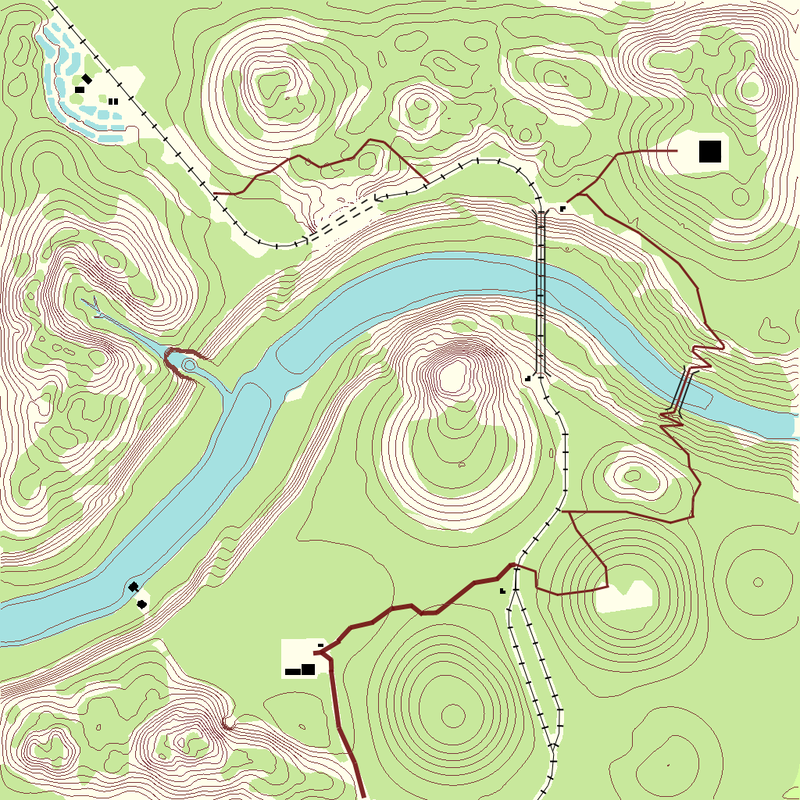
Now Clypp I've completely ruined your lovely artwork
but hopefully youll see what I'm trying to show you and can take it and work your magic with it
I've stuck on only
some map symbols that are used to describe various land features. TBH ogt is a hard map to put symbols on (unless you have a panda bear one for bamboo

)

OK so we have markings where there are craters, the bigger the markings the larger the craterfield. {East of recon post is a big one}
Cliff face markings showing "vertical" areas where youll pretty much fall off an die. see these west of south bridge.
Screes (look like lil crater fields) these are steep areas of rock which arent vertical but youll slip down them, maybe be injured. these are ESE of north bridge and West south west of south bridge (areas where you slip)
and the lil blue bits (which ended up looked like puddles, scrap that then) are what you make reeds and marshland look like (for example the marshland where you find the barrat on river qwai)
Really dont have the tools, time or ability to do anything more or better right now. but things like the vegitation change where there are trees on the shoreline and it changes to pure bamboo in the jungle, that would be on the map.
There needs to be symbols to define where those trees are and then you can see the shading of where the bamboo thicket begins.
A spot like the trenchs is somewhere youd sketch in a symbol by the CO for enemy fortifcations (Watch this space) but you wouldnt be too sure exactly whats there.
The dockhouse you may put a question mark for enemy River craft sketched on by CO again
The point is a good map of the area is more detailed thatn a satillite pic cos you have all the pictures etc. showing you where and what everything is (forget that youve played the map before and know what it is
)
I don't mean to hijack your ideas at all Clypp m8 I just wanna show you some of the authentic symbols used as I'm a keen hiker and have maps borrowed from my dad/in laws army days.
So I too am rather keen to seen some good effective Ordnance survey maps
lol
Also heres another resource for you for some symbols used
http://www.csuchico.edu/lbib/maps/MAP3.GIF


